I was sitting out in this little park/plaza on my tablet with my backpack and bags piled around me in the middle of the night. It's sort of in the middle of the bar area, and it was a Friday night (or very early Saturday morning) so there were lots of really drunk people stumbling around shouting a lot. A few came over to talk with me, but it's New Zealand, so nobody really gave me much of a hassle. Finally around 3am I walked to the corner and caught my shuttle bus to the airport. There were only 2 other people on board, and the ride was a lot faster than it had been when I flew into Auckland due to there being nobody getting on or off and no traffic. I checked in and lounged around the airport and read some more. My flight path was a bit strange. It was cheaper to go to LA through Melbourne than direct, even though going through Melbourne meant flying for hours in the wrong direction first. I'm more concerned with money than time, and spending long hours sitting in a vehicle is routine by now.
The issue in Melbourne was that I was transferring between two airlines (JetStar and Qantas), and they weren't going to transfer my backpack to the second flight automatically. This meant that I had to get my bag, queue up to go through border control, go through another queue at customs (which is very thorough in Australia), go to the Qantas desk to get my boarding pass and check my bag for the new flight, then go through more queues back through security and border control again. There was only about 1:15 between when the first flight landed and I was supposed to board the second flight, and with all the long lines that time disappeared quickly and I was feeling a little nervous (and rather tired since I still hadn't slept). Ultimately I did get there in just under the time I needed, but it turned out to be moot since there was some sort of equipment trouble and boarding was delayed 40 minutes anyway. Finally we got on the plane and it was time to head back the way I'd just come, flying east over the Pacific.
The person sitting next to me on the flight was a blind Australian who was eventually heading to Venezuela to visit hospitals and orphanages as a clown with Patch Adams. That, combined with me having been travelling the world for a year made for lots to talk about. I also watched a few movies, and got a couple hours of much needed sleep. American border control is known for being pretty thorough, so the lines were slow. When it was finally my turn, I got grilled. My passport is by now rather colourful, which seemed to make him suspcious (in Australia, people going to backpack around the world is almost part of growing up, in America, not so much). This led to him asking for additional identification, which hasn't happened anywhere else in the world. I gave him additional identification, but of course since it's me the names didn't match exactly since all my IDs are slightly different. This led to more questioning about all my aliases (no, I've never gone by the name Rico Martinez Miller) before eventually letting me continue on. I finally got into the main terminal about 7:30am on March 7, the same time and date as I'd left Auckland like 20+ hours ago (gotta love the date-line time travel flights). I took my time getting a shuttle to Union Station, and since I was still really early decided to walk to Mariachi Plaza instead of taking the subway. My hostel was across the Los Angeles River, and in a rather poor and run down Mexican/Latino area. The hostel itself was a small independent one, but the staff was friendly and it was right next to the subway. I was pretty exhausted still from all the travel and not getting much sleep on the plane, so I napped a little and just spent the day in the local area, talking with other guests in the hostel and finding some nice little restaurants in the local area. After months of craving Mexican food, bein in the Mexican part of LA certainly gave me a lot of options. I managed to put off going to bed until late, partially since it was Saturday night and there were a lot of people coming and going. Finally I got some well deserved sleep.
Showing posts with label New Zealand. Show all posts
Showing posts with label New Zealand. Show all posts
Friday, March 22, 2013

Days 346-347: Waiting to Leave
I took my last bus ride of New Zealand from Taupo, back up through Rotorua and finally to Auckland. During our hike across Tongariro our group had a lengthy discussion on New Zealand meat pies, which seem to be something of a national dish. One of the places that came up was a little bakery in Rotorua that had delicious pies, so when I happened to have an hour between transferring buses around lunch in Rotorua I managed to hunt the place down and get a few award-winning pies.

I had purposely booked a hostel a bit closer to where the buses come and go, mostly so that I wouldn't have so far to work at the dreadfully early hour I had to go at to catch my plane when I finally left the city. I didn't really have much I wanted to do in Auckland, but I did hang out in the city for much of the second day, just browsing through comic and book shops and sitting around in parks or by the water. Although I booked 2 nights in my hostel, I ultimately only slept there once. My flight from Auckland to Los Angeles left around 7am, and between the few hours early I'd have to get to the airport, the bus to get there, and the walk from my hostel to the bus stop I'd have had to get up around 3am to do everything comfortably. Instead I just walked to a nearby park where I could use wifi (my hostel was charging $10 a day to use wifi - one of the things I really hate about New Zealand) and just spent the night reading a book on my tablet and planning out the next few weeks a little.

I had purposely booked a hostel a bit closer to where the buses come and go, mostly so that I wouldn't have so far to work at the dreadfully early hour I had to go at to catch my plane when I finally left the city. I didn't really have much I wanted to do in Auckland, but I did hang out in the city for much of the second day, just browsing through comic and book shops and sitting around in parks or by the water. Although I booked 2 nights in my hostel, I ultimately only slept there once. My flight from Auckland to Los Angeles left around 7am, and between the few hours early I'd have to get to the airport, the bus to get there, and the walk from my hostel to the bus stop I'd have had to get up around 3am to do everything comfortably. Instead I just walked to a nearby park where I could use wifi (my hostel was charging $10 a day to use wifi - one of the things I really hate about New Zealand) and just spent the night reading a book on my tablet and planning out the next few weeks a little.
Thursday, March 14, 2013
Days 344-345: Resting in Taupo
Originally I'd planned to squeeze one more place in before returning to Auckland to fly out, but after all the bus rides and hiking I decided I'd rather just take things slow and just rest in Taupo for a few days then head to Auckland. The day after the hike I had breakfast with the others before they drove on back to Hamilton and I switched to a new hostel. The two days in Taupo was pretty uneventful. I went for a few walks around town and along the lake, but there isn't really much to talk about!
Day 343: Feats of Endurance
We got up around 4:30am to get read for an early morning shuttle from Taupo out to the start of the climb in Tongariro National Park. We shared the shuttle with two other people staying in Taupo, bringing our little group to 7. Tongariro is recently famous for being used for filming of Mordor and Mt. Doom in The Lord of the Rings movies, and it's something of a wasteland of dust and volcanic rock. The walk began pretty easily with winding paths through rocky fields with lots groundcovers and lichens. The mountains themselves began pretty obscured by cloud, but things cleared up quite a bit as we approached.


Once we got to the edge of the mountains things got steeper and quite a bit harder. The steepness wasn't really the problem, but in many places the ground was loose volcanic sand and gravel that slipped with every step, and through the hike we all slipped and fell down more than once. After the first climb up there's a long flat section that goes by the red crater, and a nice view down at the rocky plain on the other side of the mountains.


There was another steep climb up the next ridge before the path carried on down the other side to the emerald lakes. This steep descent wasn't too bad to go down, and normally going down is all you have to do since it's a one-way path. Unfortunately the end section of the crossing has been closed for some time do to dangerous volcanic activity, so we had to slowly climb back up the steep, shifting slope of sand.


Once climbing back up to the highest part of the walk we stopped for lunch, then retraced our path back over and out of the mountains. Once we got back to our starting point we got the shuttle back to Taupo and after returning to our hostel for showers we went down to the main area to get some dinner and drinks. As I mentioned before, this was the day of the Taupo Iron Man race, so we got a table along the course to watch and cheer people on. For those that don't know, Iron Man competitions are insane. It's like a triathalon, but they lengthen all the sections since apparently triathalons aren't hardcore enough already. The Iron Man consists of a 4km swim followed by a 180km bicycle ride. If you're not exhausted after all that, then you only have to run a full marathon of 42km afterwards to finish. I'm a little in awe of anybody that can finish one of these, even if I question their sanity a little for wanting to put themselves through it. Deserving special mention is a guy staying in our hostel that we had a bit of a chat with who was probably about 50, and only had one arm. I don't know what time he got, but we saw him well into the marathon run.


Once we got to the edge of the mountains things got steeper and quite a bit harder. The steepness wasn't really the problem, but in many places the ground was loose volcanic sand and gravel that slipped with every step, and through the hike we all slipped and fell down more than once. After the first climb up there's a long flat section that goes by the red crater, and a nice view down at the rocky plain on the other side of the mountains.


There was another steep climb up the next ridge before the path carried on down the other side to the emerald lakes. This steep descent wasn't too bad to go down, and normally going down is all you have to do since it's a one-way path. Unfortunately the end section of the crossing has been closed for some time do to dangerous volcanic activity, so we had to slowly climb back up the steep, shifting slope of sand.


Once climbing back up to the highest part of the walk we stopped for lunch, then retraced our path back over and out of the mountains. Once we got back to our starting point we got the shuttle back to Taupo and after returning to our hostel for showers we went down to the main area to get some dinner and drinks. As I mentioned before, this was the day of the Taupo Iron Man race, so we got a table along the course to watch and cheer people on. For those that don't know, Iron Man competitions are insane. It's like a triathalon, but they lengthen all the sections since apparently triathalons aren't hardcore enough already. The Iron Man consists of a 4km swim followed by a 180km bicycle ride. If you're not exhausted after all that, then you only have to run a full marathon of 42km afterwards to finish. I'm a little in awe of anybody that can finish one of these, even if I question their sanity a little for wanting to put themselves through it. Deserving special mention is a guy staying in our hostel that we had a bit of a chat with who was probably about 50, and only had one arm. I don't know what time he got, but we saw him well into the marathon run.
Sunday, March 10, 2013
Days 341-342: Wellington to Taupo
I spent a day hanging out in Wellington to recover a bit from all the non-stop travelling. The weather in Wellington has been pretty amazing every day I've been there, and it was a nice warm sunny day. I didn't have any real plans or objectives, and was happy to just explore around downtown and along the harbor. The only really notable encounter of the day was with a tiny baby penguin that seemed to be wandering alone in the rocks down along the water, but it was unfortunately one of the times I didn't have my camera with me.
The next morning I took the morning bus from Wellington up to Taupo, where I was going to be meeting some locals to visit Tongariro National Park. Taupo is another fairly small town (similar to Owen Sound in population), sitting on the picturesque Lake Taupo. Our accomodations and transportation for the hike at Tongariro was entirely set up by Claire, who I think is the only person I've met in 4 different countries now - China, Hong Kong, Nepal and New Zealand (I can only think of 4 people, 3 of whom are family, that I've even met in 3 countries). She lives fairly close to Taupo and had been wanting to do the hike, so when I got to New Zealand we picked a suitable date and she did all the hard work, which was especially notable because the weekend we picked happened to also be the weekend of the Taupo Iron Man competition, and almost everything in town was booked solid. In the end our group was 5 people (including 3 of her friends from nearby Hamilton), and we met up in the evening at our lodging for the night before going out to pick up some groceries for the hike.
The next morning I took the morning bus from Wellington up to Taupo, where I was going to be meeting some locals to visit Tongariro National Park. Taupo is another fairly small town (similar to Owen Sound in population), sitting on the picturesque Lake Taupo. Our accomodations and transportation for the hike at Tongariro was entirely set up by Claire, who I think is the only person I've met in 4 different countries now - China, Hong Kong, Nepal and New Zealand (I can only think of 4 people, 3 of whom are family, that I've even met in 3 countries). She lives fairly close to Taupo and had been wanting to do the hike, so when I got to New Zealand we picked a suitable date and she did all the hard work, which was especially notable because the weekend we picked happened to also be the weekend of the Taupo Iron Man competition, and almost everything in town was booked solid. In the end our group was 5 people (including 3 of her friends from nearby Hamilton), and we met up in the evening at our lodging for the night before going out to pick up some groceries for the hike.
Saturday, March 9, 2013
Days 339-340: Northward Blitz
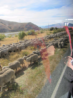
It was now time to blitz back across New Zealand, or at least the south island. I first took a long bus ride from Queenstown up to Christchurch, delayed slightly be a huge herd of sheep that wouldn't get off the road.
I was curious to see what Christchurch would look like now, after it suffered so much destruction from the earthquakes. At first, it doesn't look that different, but then you start to notice all the empty lots and the fact that there really aren't many buildings more than 2 stories tall. The hostel was nice enough to come pick me up from downtown and drive me to the hostel, and the driver/owner was pointing out all the buildings that have been torn down, or are going to be torn down because the foundations are no longer safe.

The hostel itself was... interesting. Because there's been so much damage to the infrustructure there's a combination of not enough accomodations in town and a lot of people coming into the city looking for construction work, causing a huge shortage of beds. The hostel I was in had addressed this by having tents spread all through the backyard, with big outdoor communal areas under tarps. I was in a more traditional dorm room inside the house, but spent the evening hanging out with a lot of the campers. It had a very hippie commune vibe to it, and included lots of random drum circles and impromptu sing-a-longs.
My bus in the morning was at an annoying 7am, so I had to take a taxi from the hostel. About 2/3 of the way to Picton the bus came to a sputtering stop, and died. The driver tried a few things, but ultimately gave up and told us that they were looking for an alternative, but that anybody going to the ferry was going to miss it. I was mentally trying to figure out all the things I was going to have to shift, when one of the other passengers who happened to be a mechanic managed to get the bus going again. We rushed on north and I managed to catch the ferry and cross back over to Wellington. I just had time to get to my hostel, drop off my bags and have a quick shower before I met up with my childhood friend Alan and his girlfriend for dinner, as they happened to be heading down south as I was coming north. If you can't reconnect with old friends on the other side of the world, where can you?
Overall, a really long 2 days.

I was curious to see what Christchurch would look like now, after it suffered so much destruction from the earthquakes. At first, it doesn't look that different, but then you start to notice all the empty lots and the fact that there really aren't many buildings more than 2 stories tall. The hostel was nice enough to come pick me up from downtown and drive me to the hostel, and the driver/owner was pointing out all the buildings that have been torn down, or are going to be torn down because the foundations are no longer safe.

The hostel itself was... interesting. Because there's been so much damage to the infrustructure there's a combination of not enough accomodations in town and a lot of people coming into the city looking for construction work, causing a huge shortage of beds. The hostel I was in had addressed this by having tents spread all through the backyard, with big outdoor communal areas under tarps. I was in a more traditional dorm room inside the house, but spent the evening hanging out with a lot of the campers. It had a very hippie commune vibe to it, and included lots of random drum circles and impromptu sing-a-longs.
My bus in the morning was at an annoying 7am, so I had to take a taxi from the hostel. About 2/3 of the way to Picton the bus came to a sputtering stop, and died. The driver tried a few things, but ultimately gave up and told us that they were looking for an alternative, but that anybody going to the ferry was going to miss it. I was mentally trying to figure out all the things I was going to have to shift, when one of the other passengers who happened to be a mechanic managed to get the bus going again. We rushed on north and I managed to catch the ferry and cross back over to Wellington. I just had time to get to my hostel, drop off my bags and have a quick shower before I met up with my childhood friend Alan and his girlfriend for dinner, as they happened to be heading down south as I was coming north. If you can't reconnect with old friends on the other side of the world, where can you?
Overall, a really long 2 days.
Days 337-338: The Divide and Return
The final day was from Lake Mackenzie to a place called The Divide, which is where a few different trails begin. It was mostly in woods again, so the views weren't as spectacular, but it was still a nice woodland track. The one notable exception was another steep side tail up to Key Summit which climbed back above the tree line to an alpine marsh preservation. In addition to all the lovely mountain views it was also new flora with lots of different colourful mosses and groundcovers.


From there it was a steady descent down through the forest. Closer to the Divide there were lots of other hikers who take a bus out, hike for a couple hours then go home. I think they miss all the best parts of the hike, but not everybody has the time, desire or fitness to do the entire thing. I got picked up a couple hours after finishing the track, and got driven back to Queenstown in a much longer journey than the one that brought me in.
Back in Queenstown I returned my sleeping bag and decided to book an extra day in the city to relax and look around a bit. I tried to get dinner at this famous burger restaurant called Fergburger. It's not only famous in the city, but had been recommended to me even by people on the other side of the country. Unfortunately I'm not the only person looking to try it out, and the line was too daunting to get one. Instead, I waited until the morning and went and had a massive, delicious burger there at 9:30 in the morning when there was no line at all!


The rest of my day was pretty uneventful. I visited the small beach in town and just hung out relaxing.


From there it was a steady descent down through the forest. Closer to the Divide there were lots of other hikers who take a bus out, hike for a couple hours then go home. I think they miss all the best parts of the hike, but not everybody has the time, desire or fitness to do the entire thing. I got picked up a couple hours after finishing the track, and got driven back to Queenstown in a much longer journey than the one that brought me in.
Back in Queenstown I returned my sleeping bag and decided to book an extra day in the city to relax and look around a bit. I tried to get dinner at this famous burger restaurant called Fergburger. It's not only famous in the city, but had been recommended to me even by people on the other side of the country. Unfortunately I'm not the only person looking to try it out, and the line was too daunting to get one. Instead, I waited until the morning and went and had a massive, delicious burger there at 9:30 in the morning when there was no line at all!


The rest of my day was pretty uneventful. I visited the small beach in town and just hung out relaxing.
Day 336: Routeburn Falls to Lake Mackenzie
The second day was the longest hike, from Routeburn Falls up across the saddle between mountains, crossing from Mt. Aspiring National Park into Fjordlands National Park, around the back of the mountain range and down to Lake Mackenzie. The morning began with very poor visibility as we were right in the middle of the clouds. I was too restless to wait them out, but didn't want to miss the best views of the hike, so I walked slowly in the morning and took lots of breaks to sit and wait as long as I could manage before getting restless again. My delay did pay off as around 11am little pockets of blue appeared, and then within 15 minutes the entire sky was clear.


The next hour or so of hiking was my favourite of the track as you cross through another valley, and head up through another mountain pass that has a glacial lake nestled inside.


Past the lake, on the final saddly of the range was a little day-shelter that marks the switch from one park to the other. There's also a side trail that leads up to the peak of Conical Hill. Conical Hill only takes 30 or 40 minutes to go up, but it's a steep, hard climb. The view from the top lets you see in all directions though, so it was a worthwhile sidetrip.


The entire day so far had been above the tree-line, and that continued as the path crossed over to the other side of the mountains and hugged along the side. There was a new view of more mountains and a river valley down below, with forest between the alpine grasses around the path and the valley below.


Finally the path curved around the side of the mountains and revealed Lake Mackenzie down below. Then it was a series of cross-backs down the mountain that was hard on my knees. Towards the bottom the path went through an amazing mossy forest of silver beech trees that is nicknamed the "Fairy Glen". Unfortunately it's pretty impossible to capture it properly with my camera (like just about everything on this hike).


After grabbing a bunk (I was one of the first there, so I managed to get one of the good ones) I headed over to the lake for a swim. There was a group of Germans waffling over the temperature of the water, and I swear it took them all least 10 minutes to finally work up will to jump in after standing with the water up to their knees. I just walked down a log and jumped in, and while it was cold it wasn't that bad, and certainly not as bad as many places I've swam. Wussy Germans.
Each of the bunk houses has a park warden stationed at them. It's their job to look after the bunk house and check tickets, but more importantly they also maintain the track and look after the surrounding parks. The guy on our first night had just given us a talk on fire safety, but the one at Lake Mackenzie is something of a legend in the parks. He's worked at Lake Mackenzie for 20 years, and runs an annual Christmas dinner and Highland Games competition that brings the other park wardens in from all over the country. His talk was a mix of annecdotes, information and stand up comedy (for the most part absolutely deadpan) that was absolutely hilarious in addition to being very informative.


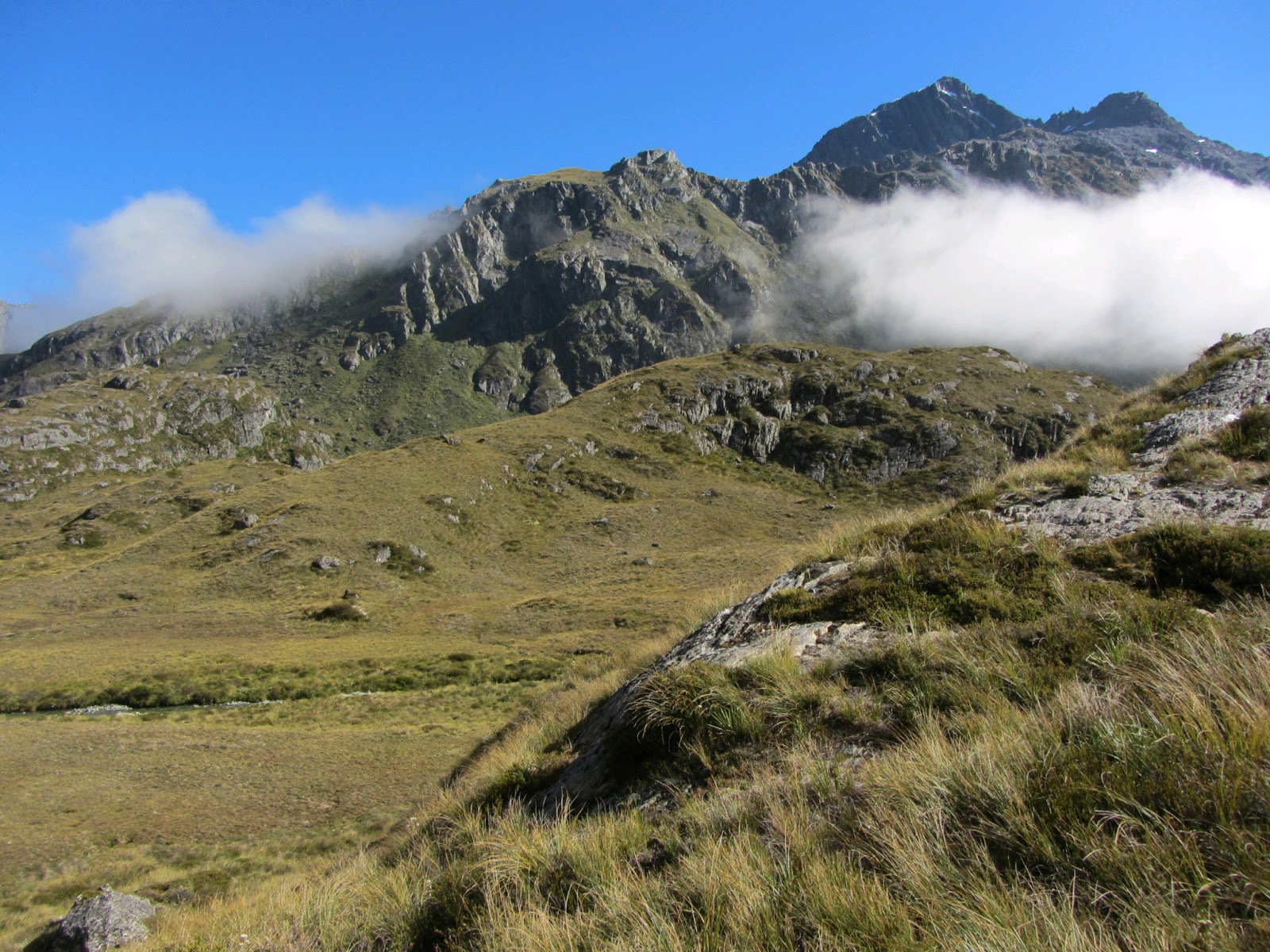
The next hour or so of hiking was my favourite of the track as you cross through another valley, and head up through another mountain pass that has a glacial lake nestled inside.


Past the lake, on the final saddly of the range was a little day-shelter that marks the switch from one park to the other. There's also a side trail that leads up to the peak of Conical Hill. Conical Hill only takes 30 or 40 minutes to go up, but it's a steep, hard climb. The view from the top lets you see in all directions though, so it was a worthwhile sidetrip.


The entire day so far had been above the tree-line, and that continued as the path crossed over to the other side of the mountains and hugged along the side. There was a new view of more mountains and a river valley down below, with forest between the alpine grasses around the path and the valley below.


Finally the path curved around the side of the mountains and revealed Lake Mackenzie down below. Then it was a series of cross-backs down the mountain that was hard on my knees. Towards the bottom the path went through an amazing mossy forest of silver beech trees that is nicknamed the "Fairy Glen". Unfortunately it's pretty impossible to capture it properly with my camera (like just about everything on this hike).


After grabbing a bunk (I was one of the first there, so I managed to get one of the good ones) I headed over to the lake for a swim. There was a group of Germans waffling over the temperature of the water, and I swear it took them all least 10 minutes to finally work up will to jump in after standing with the water up to their knees. I just walked down a log and jumped in, and while it was cold it wasn't that bad, and certainly not as bad as many places I've swam. Wussy Germans.
Each of the bunk houses has a park warden stationed at them. It's their job to look after the bunk house and check tickets, but more importantly they also maintain the track and look after the surrounding parks. The guy on our first night had just given us a talk on fire safety, but the one at Lake Mackenzie is something of a legend in the parks. He's worked at Lake Mackenzie for 20 years, and runs an annual Christmas dinner and Highland Games competition that brings the other park wardens in from all over the country. His talk was a mix of annecdotes, information and stand up comedy (for the most part absolutely deadpan) that was absolutely hilarious in addition to being very informative.
Day 335: Routeburn
In the morning I went to one of the many hiking companies around and rented a sleeping back for the 3 days I needed to do my hike. I'd picked up a bit of food in Franz Josef, but I got a few more things just to be safe. This hike wasn't the longest or hardest I'd done, but I had the heaviest pack for it since I had to carry all my food, sleeping bag and extra clothes. Snow was unexpected at this time of year, but not unheard of, and to be safe I had to bring cold weather and wet weather clothes. My shuttle didn't leave until 12:30, and didn't get to the start of the hike until 2pm, but in the direction I was going the first day was the shortest, so I wasn't worried about the time.
The first couple hours were a slow, leisurely climb through forest, following along a river. The highlight of this stretch for me was a brief section where the path exited out of the woods into a field surrounded on all sides by mountains. I took a break here for a snack and to just spend 20 minutes sitting and enjoying the scenery.


Awhile later there was a turn off for the campground, but the hut I was staying was still a good hike away. Just beyond the campground the path really started to climb, and it was an hour of solid climbing uphill before I got to my place for the night. The bunkhouses are buildings that can bunk about 50 people, but they don't have any bedding or food. They have to be reserved well in advance to get a spot (I got a bit lucky being able to do the hike at all), but they have cooking facilities and toilets, so it's a nice middle-ground. The bunkhouse was at Routeburn Falls, which in addition to being a nice waterfall gave a beautiful view down at the valley I'd spent the afternoon walking through.


The first couple hours were a slow, leisurely climb through forest, following along a river. The highlight of this stretch for me was a brief section where the path exited out of the woods into a field surrounded on all sides by mountains. I took a break here for a snack and to just spend 20 minutes sitting and enjoying the scenery.


Awhile later there was a turn off for the campground, but the hut I was staying was still a good hike away. Just beyond the campground the path really started to climb, and it was an hour of solid climbing uphill before I got to my place for the night. The bunkhouses are buildings that can bunk about 50 people, but they don't have any bedding or food. They have to be reserved well in advance to get a spot (I got a bit lucky being able to do the hike at all), but they have cooking facilities and toilets, so it's a nice middle-ground. The bunkhouse was at Routeburn Falls, which in addition to being a nice waterfall gave a beautiful view down at the valley I'd spent the afternoon walking through.


Tuesday, March 5, 2013
Day 334: Queenstown
The bus from Franz Josef didn't leave until the afternoon, but it was another nice drive further south, getting deeper into the mountains and woods and parks. We got into Queenstown in the evening around 8pm. Because its surrounded by beautiful mountains and water it's a pretty touristy place, and the city center is full of restaurants, bars and travel companies. I had been planning to do a fairly big hike out of Queenstown, and had planned to get here a day earlier to get the gear I needed and get organized. Unfortunately that got delayed because of the bus being full, so I had a shuttle scheduled for 8am the next morning without a lot of the things still to be figured out. I managed to at least change my shuttle to 12:30pm, which would obviously mean I started the hike later but would give me time in the morning to get organized and buy supplies before I headed out.
Sunday, March 3, 2013
Days 332-333: Franz Josef
After my break in Nelson it was back onto the road heading down along the west coast. The scenery for the trip was fantastic as we had the ocean on one side and the mountains on the other. All these long bus rides include breaks along the way for meals and to use toilets, and one of our stops happened to be at Punakaiki, also known as the Pancake Rocks. The entire circuit past the rocks would take longer than the 15 minutes I had, but I had enough time to walk down and see what they were all about at least.


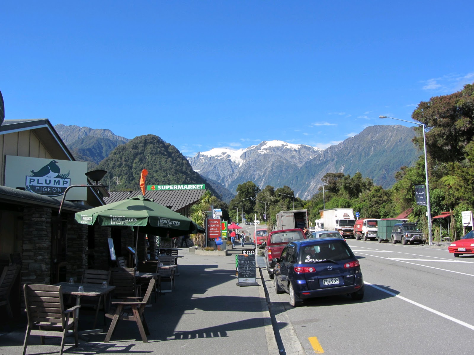
A few more hours later we finally made it into Franz Josef. Franz Josef isn't even a town, it's just two short streets along the highway. The only reason it's really there is for tourists visiting the Franz Josef glacier which sits in the mountains a short distance away. It was late afternoon by the time my bus got in so I wasn't planning to do much for that day. I checked into my accomodations and went for a short walk down a nearby trail but decided to leave the glacier for the next day. It really is lovely scenery though with all the woods backed by snow-capped mountains, and no tall buildings to spoil the view.

The next day I went to visit the glacier. There are shuttles that take you to the parking lot for the place, but they are $12 each way and I'm cheap, so I just decided to walk. It's about a 5km walk to the parking lot, and then another few kilometers through the woods and through a rocky valley created by the retreating glacier. There's a river running through the valley and it's pretty amazing how much water is coming from the glacier. For safety reasons you can't go all the way up to the glacier, but I followed the path as far as it goes to get a better view.


There were a few other really cool activities offered from Franz Josef. You could do skydiving, or take a helicopter up to drop you off on the glacier and do day hikes over the ice and through glacial tunnels. Unfotunately both of these activities were a bit beyond what I was willing to spend, so I had to be satisfied with just seeing things from afar.


A few more hours later we finally made it into Franz Josef. Franz Josef isn't even a town, it's just two short streets along the highway. The only reason it's really there is for tourists visiting the Franz Josef glacier which sits in the mountains a short distance away. It was late afternoon by the time my bus got in so I wasn't planning to do much for that day. I checked into my accomodations and went for a short walk down a nearby trail but decided to leave the glacier for the next day. It really is lovely scenery though with all the woods backed by snow-capped mountains, and no tall buildings to spoil the view.
The next day I went to visit the glacier. There are shuttles that take you to the parking lot for the place, but they are $12 each way and I'm cheap, so I just decided to walk. It's about a 5km walk to the parking lot, and then another few kilometers through the woods and through a rocky valley created by the retreating glacier. There's a river running through the valley and it's pretty amazing how much water is coming from the glacier. For safety reasons you can't go all the way up to the glacier, but I followed the path as far as it goes to get a better view.


There were a few other really cool activities offered from Franz Josef. You could do skydiving, or take a helicopter up to drop you off on the glacier and do day hikes over the ice and through glacial tunnels. Unfotunately both of these activities were a bit beyond what I was willing to spend, so I had to be satisfied with just seeing things from afar.
Days 330-331: Extended Stay
My original plan had been to spend 3 nights in Nelson before heading down the west coast of the south island, but the bus service I'm using only has one bus a day going in the direction I wanted, and it was already full on the day I wanted to leave. Like just about everywhere in New Zealand, Nelson is a nice, relaxed town and staying a 4th night wasn't much of an issue.
On Sunday I walked along the coast for a couple hours to the beach. After spending a couple hours relaxing on the beach I met up with a group I had been told about by one of the hostel staff to play ultimate frisbee in the sand. I haven't played ultimate frisbee since university, and while my cardio is immensly better for some activities now, sprinting back and forth in the sand for 3 hours isn't one of them. My throwing was a little rough but my catching was still very sharp and it was a lot of fun. After the frisbee we went out to a local pub to hang out and have a few drinks and then I got a ride back to the hostel from one of the other players.

I was a little sore the next day, but wasn't too bad. I didn't really have much planned at this point but a few of the hostel newcomers were looking for things to do so I showed them around town and did a bit more hiking on the trails just outside of town.
On Sunday I walked along the coast for a couple hours to the beach. After spending a couple hours relaxing on the beach I met up with a group I had been told about by one of the hostel staff to play ultimate frisbee in the sand. I haven't played ultimate frisbee since university, and while my cardio is immensly better for some activities now, sprinting back and forth in the sand for 3 hours isn't one of them. My throwing was a little rough but my catching was still very sharp and it was a lot of fun. After the frisbee we went out to a local pub to hang out and have a few drinks and then I got a ride back to the hostel from one of the other players.

I was a little sore the next day, but wasn't too bad. I didn't really have much planned at this point but a few of the hostel newcomers were looking for things to do so I showed them around town and did a bit more hiking on the trails just outside of town.
Day 329: The Center of New Zealand
There's a pretty popular farmer's market in Nelson each week on Saturday, and it being Saturday I decided to begin my day checking it out. It was a nice mixture of fresh produce, food stands, clothing, arts and crafts and other bits and pieces. I was tempted by some of the wool clothes, but talked myself out of it and settled on a delicious food stand burrito and an ice cream cone instead.

Next I visited a large park past the hostel because it had been recommended to me as the starting point of a few good hikes in the area. There was a game of cricket going on in the park that I sat and watched for awhile in an attempt to flesh out my slowly improving understand of the sport. I then found the Center of New Zealand trail, which takes you up one of the adjacent hills to what has been established as the centermost point of the country, I guess. Somebody in the hostel had told me it was a short but challenging hike, but in reality it was more just a stroll up a wooded hill. I walked up, enjoyed the view for a bit then came back down in under an hour, but it was still nice to stretch my legs after all the time on ferries and buses, and it did provide a nice view of the surroundings.


Next I visited a large park past the hostel because it had been recommended to me as the starting point of a few good hikes in the area. There was a game of cricket going on in the park that I sat and watched for awhile in an attempt to flesh out my slowly improving understand of the sport. I then found the Center of New Zealand trail, which takes you up one of the adjacent hills to what has been established as the centermost point of the country, I guess. Somebody in the hostel had told me it was a short but challenging hike, but in reality it was more just a stroll up a wooded hill. I walked up, enjoyed the view for a bit then came back down in under an hour, but it was still nice to stretch my legs after all the time on ferries and buses, and it did provide a nice view of the surroundings.


Subscribe to:
Posts (Atom)